Aurora


Aurora (phenomenon), luminous atmospheric phenomenon occurring most frequently above 60° North or South latitude, but also in other parts of the world. It is named specifically, according to its location, aurora borealis (northern lights) or aurora australis (southern lights). The term aurora polaris, polar lights, is a general name for both.

The aurora consists of rapidly shifting patches and dancing columns of light of various hues. Extensive auroral displays are accompanied by disturbances in terrestrial magnetism and interference with radio, telephone, and telegraph transmission. The period of maximum and minimum intensity of normal auroras seems to be almost exactly opposite that of the sunspot cycle, which is an 11-year cycle, so the intensity of the auroras is normally low while the sun is very active. Huge displays that occur farther from the earth’s poles than normal, however, occur more often while the sun is very active.

Cloud


Cloud, condensed form of atmospheric moisture consisting of small water droplets or tiny ice crystals. Clouds are the principal visible phenomena of the atmosphere. They represent a transitory but vital step in the water cycle, which includes evaporation of moisture from the surface of the earth, carrying of this moisture into higher levels of the atmosphere, condensation of water vapor into cloud masses, and final return of water to the surface as precipitation.


Topics:

High Clouds


These are clouds composed of ice particles, found at average levels of 8 km (5 mi) or more above the earth. The family contains three principal genera. Cirrus clouds are isolated, feathery, and threadlike, often with hooks or tufts, and are arranged in bands. Cirrostratus clouds appear as a fine, whitish veil; they occasionally exhibit a fibrous structure and, when situated between the observer and the moon, produce halo phenomena. Cirrocumulus clouds form small, white, fleecy balls and wisps, arranged in groups or rows. Cirrocumulus and cirrus clouds are popularly described by the phrase “mackerel scales and mares' tails.”

Middle Clouds


These are clouds composed of water droplets and ranging in altitude from about 3 to 6 km (about 2 to 4 mi) above the earth. Two principal genera are included in the family. Altostratus clouds appear as a thick, gray or bluish veil, through which the sun or moon may be seen only diffusely, as through a frosted glass. Altocumulus clouds have the appearance of dense, fleecy balls or puffs somewhat larger than cirrocumulus. The sun or moon shining through altocumulus clouds may produce a corona, or colored ring, markedly smaller in diameter than a halo.

Low Clouds


These clouds, also composed of water droplets, are generally less than 1.6 km (1 mi) high. Three principal forms comprise this group. Stratocumulus clouds consist of large rolls of clouds, soft and gray looking, which frequently cover the entire sky. Because the cloud mass is usually not very thick, blue sky often appears between breaks in the cloud deck. Nimbostratus clouds are thick, dark, and shapeless. They are precipitation clouds from which, as a rule, rain or snow falls. Stratus clouds are sheets of high fog. They appear as flat, white blankets, usually less than 610 m (2000 ft) above the ground. When they are broken up by warm, rising air, the sky beyond usually appears clear and blue.

Clouds With Vertical Development


Clouds of this type range in height from less than 1.6 km (1 mi) to more than 13 km (8 mi) above the earth. Two main forms are included in this group. Cumulus clouds are dome-shaped, woolpack clouds most often seen during the middle and latter part of the day, when solar heating produces the vertical air currents necessary for their formation. These clouds usually have flat bases and rounded, cauliflowerlike tops. Cumulonimbus clouds are dark, heavy-looking clouds rising like mountains high into the atmosphere, often showing an anvil-shaped veil of ice clouds, false cirrus, at the top. Popularly known as thunderheads, cumulonimbus clouds are usually accompanied by heavy, abrupt showers.

An anomalous, but exceptionally beautiful, group of clouds contains the nacreous, or mother-of-pearl, clouds, which are 19 to 29 km (12 to 18 mi) high, and the noctilucent clouds, 51 to 56 km (32 to 35 mi) high. These very thin clouds may be seen only between sunset and sunrise and are visible only in high latitudes.

The development of the high-altitude airplane has introduced a species of artificial clouds known as contrails (condensation trails). They are formed from the condensed water vapor ejected as a part of the engine-exhaust gases.

Dam


Dam, structure that blocks the flow of a river, stream, or other waterway. Some dams divert the flow of river water into a pipeline, canal, or channel. Others raise the level of inland waterways to make them navigable by ships and barges. Many dams harness the energy of falling water to generate electric power. Dams also hold water for drinking and crop irrigation, and provide flood control.

See also:

Types of Dams


Dams are classified by the type of material used in their construction and by their shape. Dams can be constructed from concrete, stone masonry, loose rock, earth, wood, metal, or a combination of these materials. Engineers build dams of different types, depending on the conditions of the riverbed, the geology of the surrounding terrain, the availability of construction materials, and the availability of workers. When more than one type of dam will suffice, engineers often opt to construct a type that they have built previously.

A. Gravity Dams

Gravity dams use only the force of gravity to resist water pressure—that is, they hold back the water by the sheer force of their weight pushing downward. To do this, gravity dams must consist of a mass so heavy that the water in a reservoir cannot push the dam downstream or tip it over. They are much thicker at the base than the top—a shape that reflects the distribution of the forces of the water against the dam. As water becomes deeper, it exerts more horizontal pressure on the dam. Gravity dams are relatively thin near the surface of the reservoir, where the water pressure is light. A thick base enables the dam to withstand the more intense water pressure at the bottom of the reservoir.

B. Embankment Dams

An embankment dam is a gravity dam formed out of loose rock, earth, or a combination of these materials. The upstream and downstream slopes of embankment dams are flatter than those of concrete gravity dams. In essence, they more closely match the natural slope of a pile of rocks or earth.

Of the many different kinds of embankment dams that exist, rock-fill embankment dams and zoned-embankment dams are among the most common. Rock-fill embankment dams consist of a mound of loose rock covered with a waterproof layer on the upstream side to prevent excessive seepage and erosion. The waterproof layer may be made of concrete, flat stone panels, or other impervious materials. Zoned-embankment dams include an impervious core surrounded by a mound of material that water can penetrate. The supporting mound is usually made of loose rock or earth. The core might be built from concrete, steel, clay, or any impervious materials.

C. Arch Dams

Arch dams are concrete or masonry structures that curve upstream into a reservoir, stretching from one wall of a river canyon to the other. This design, based on the same principles as the architectural arch and vault, transfers some water pressure onto the walls of the canyon. Arch dams require a relatively narrow river canyon with solid rock walls capable of withstanding a significant amount of horizontal thrust. These dams do not need to be as massive as gravity dams because the canyon walls carry part of the pressure exerted by the reservoir.

D. Buttress Dams

A buttress dam consists of a wall, or face, supported by several buttresses on the downstream side. The vast majority of buttress dams are made of concrete that is reinforced with steel. Buttresses are typically spaced across the dam site every 6 to 30 m (20 to 100 ft), depending upon the size and design of the dam. Buttress dams are sometimes called hollow dams because the buttresses do not form a solid wall stretching across a river valley.

Dam: Ecological Impact


Building a dam changes the ecology of the surrounding area. Among the most affected animals are fish that depend on free-flowing water to live. Some kinds of salmon, trout, and other fish species migrate downstream to spend part of their lives in the open ocean. As adults, they return upstream to lay their eggs in the gravel bottoms of the rivers where they were born. Large dams block the passage of such migratory fish.

Some dams incorporate a fish pass to allow fish a chance to swim around the dam and reach upstream spawning grounds. Fish passes called fish ladders comprise a series of small pools arranged like stair steps. Each pool is slightly higher than the previous one. Fish ladders are based on the idea that a fish swimming upstream cannot leap over a dam that is more than about 5 meters high, but it can leap up a series of pools, each slightly higher than the one below it. Despite fish passes and other efforts to help fish bypass dams, the cumulative effect of multiple dams built along the length of a river can exact a heavy toll on fish populations. In rivers blocked by many dams, salmon populations have dropped by as much as 95 percent, a decline many experts attribute, at least in part, to dams.

Dams also alter the water temperatures and microhabitats downstream. Water released from behind dams usually comes from close to the bottom of the reservoirs, where little sunlight penetrates. This frigid water significantly lowers the temperatures of sun-warmed shallows downstream, rendering them unfit for certain kinds of fish and other wildlife. Natural rivers surge and meander, creating small pools and sandbars that provide a place for young fish, insects, and other river-dwelling organisms to flourish. But dams alter the river flow, eliminating these microhabitats and, in some cases, their inhabitants.

Dams prevent nutrient-laden silt from flowing downstream and into river valleys. Water in a fast-moving river carries tiny particles of soil and organic material. When the water reaches a pool or a flat section of a river course, it slows down. As it slows, the organic matter it carries drops to the river bottom or accumulates along the banks. Following heavy rains or snowmelt, rivers spill over their banks and deposit organic matter on their floodplains, creating rich, fertile soil. Some of the organic matter makes it all the way to river mouths, where it settles into the rich mud of estuaries, ecosystems that nourish up to one-half of the living matter in the world’s oceans. Large dams artificially slow water to a near standstill, causing the organic matter to settle to the bottom of the reservoir. In such cases, downstream regions are deprived of nutrient-laden silt.

Dams can also wreak havoc on human populations. Reservoirs created by dams can inundate entire riverside communities that may be centuries old and filled with rich archaeological treasures. Community inhabitants are forced to seek out new places to live and work. Even those who do not have to leave suffer from forced change. People who depend on rivers for their livelihood may need to change their way of life when dams destroy natural river flows.

Earth's Atmosphere

The atmosphere is a layer of different gases that extends from Earth’s surface to the exosphere, the outer limit of the atmosphere, about 9,600 km (6,000 mi) above the surface. Near Earth’s surface, the atmosphere consists almost entirely of nitrogen (78 percent) and oxygen (21 percent). The remaining 1 percent of atmospheric gases consists of argon (0.9 percent); carbon dioxide (0.03 percent); varying amounts of water vapor; and trace amounts of hydrogen, nitrous oxide, ozone, methane, carbon monoxide, helium, neon, krypton, and xenon.

Layers of the Atmosphere

The layers of the atmosphere are the troposphere, the stratosphere, the mesosphere, the thermosphere, and the exosphere. The troposphere is the layer in which weather occurs and extends from the surface to about 16 km (about 10 mi) above sea level at the equator. Above the troposphere is the stratosphere, which has an upper boundary of about 50 km (about 30 mi) above sea level. The layer from 50 to 90 km (30 to 60 mi) is called the mesosphere. At an altitude of about 90 km, temperatures begin to rise. The layer that begins at this altitude is called the thermosphere because of the high temperatures that can be reached in this layer (about 1200°C, or about 2200°F). The region beyond the thermosphere is called the exosphere. The thermosphere and the exosphere overlap with another region of the atmosphere known as the ionosphere, a layer or layers of ionized air extending from almost 60 km (about 50 mi) above Earth’s surface to altitudes of 1,000 km (600 mi) and more.

Earth’s atmosphere and the way it interacts with the oceans and radiation from the Sun are responsible for the planet’s climate and weather. The atmosphere plays a key role in supporting life. Almost all life on Earth uses atmospheric oxygen for energy in a process known as cellular respiration, which is essential to life. The atmosphere also helps moderate Earth’s climate by trapping radiation from the Sun that is reflected from Earth’s surface. Water vapor, carbon dioxide, methane, and nitrous oxide in the atmosphere act as “greenhouse gases.” Like the glass in a greenhouse, they trap infrared, or heat, radiation from the Sun in the lower atmosphere and thereby help warm Earth’s surface. Without this greenhouse effect, heat radiation would escape into space, and Earth would be too cold to support most forms of life.

Other gases in the atmosphere are also essential to life. The trace amount of ozone found in Earth’s stratosphere blocks harmful ultraviolet radiation from the Sun. Without the ozone layer, life as we know it could not survive on land. Earth’s atmosphere is also an important part of a phenomenon known as the water cycle or the hydrologic cycle. See also Atmosphere.

The Atmosphere and the Water Cycle

The water cycle simply means that Earth’s water is continually recycled between the oceans, the atmosphere, and the land. All of the water that exists on Earth today has been used and reused for billions of years. Very little water has been created or lost during this period of time. Water is constantly moving on Earth’s surface and changing back and forth between ice, liquid water, and water vapor.

The water cycle begins when the Sun heats the water in the oceans and causes it to evaporate and enter the atmosphere as water vapor. Some of this water vapor falls as precipitation directly back into the oceans, completing a short cycle. Some of the water vapor, however, reaches land, where it may fall as snow or rain. Melted snow or rain enters rivers or lakes on the land. Due to the force of gravity, the water in the rivers eventually empties back into the oceans. Melted snow or rain also may enter the ground. Groundwater may be stored for hundreds or thousands of years, but it will eventually reach the surface as springs or small pools known as seeps. Even snow that forms glacial ice or becomes part of the polar caps and is kept out of the cycle for thousands of years eventually melts or is warmed by the Sun and turned into water vapor, entering the atmosphere and falling again as precipitation. All water that falls on land eventually returns to the ocean, completing the water cycle.
See: Earth

Earth's Surface

Earth’s surface is the outermost layer of the planet. It includes the hydrosphere, the crust, and the biosphere.

Soil Management

.
Soil Management is the basis of all scientific agriculture, which involves six essential practices: proper tillage; maintenance of a proper supply of organic matter in the soil; maintenance of a proper nutrient supply; control of soil pollution; maintenance of the correct soil acidity; and control of erosion.

TILLAGE

The purpose of tillage is to prepare the soil for growing crops. This preparation is traditionally accomplished by using a plow that cuts into the ground and turns over the soil. This removes or kills any weeds growing in the area, loosens and breaks up the surface layers of the soil, and provides a bed of soil that holds sufficient moisture to permit the planted seeds to germinate. Traditional tillage may harm the soil if used continuously over many years, especially if the fertile topsoil layer is thin.

MAINTENANCE OF ORGANIC MATTER

Organic matter is important in maintaining good physical conditions in the soil. It contains the entire soil reserve of nitrogen and significant amounts of other nutrients, such as phosphorus and sulfur. Soil productivity thus is affected markedly by the organic-matter balance maintained in the soil. Because most of the cultivated vegetation is harvested instead of being left to decay, organic materials that would ordinarily enter the soil upon plant decomposition are lost. To compensate for this loss, various standardized methods are employed. The two most important of these methods are crop rotation and artificial fertilization.

NUTRIENT SUPPLY

Among soil deficiencies that affect productivity, deficiency of nutrients is especially important. The nutrients most necessary for proper plant growth are nitrogen, potassium, phosphorus, iron, calcium, sulfur, and magnesium, all of which usually exist in most soils in varying quantities. In addition, most plants require minute amounts of substances known as trace elements, which are present in the soil in very small quantities and include manganese, zinc, copper, and boron. Nutrients often occur in the soil in compounds that cannot be readily utilized by plants.

SOIL POLLUTION

Soil pollution is the buildup in soils of persistent toxic compounds, chemicals, salts, radioactive materials, or disease-causing agents, which have adverse effects on plant growth and animal health. As of now, soil pollution is not widespread. Although the application of fertilizers containing the primary nutrients, nitrogen, phosphorus, and potassium, has not led to soil pollution, the application of trace elements has. The irrigation of arid lands often leads to pollution with salts. Sulfur from industrial wastes has polluted soils in the past, as has the accumulation of arsenic compounds in soils following years of spraying crops with lead arsenate. The application of pesticides has also led to short-term soil pollution. See Environment.

Understanding Soil

Healthy soil is indispensable for a healthy garden. Plants derive water, oxygen for their roots, and essential nutrients from the soil. Soil consists of two components: minerals from weathered rocks and organic matter from decayed organisms and animal wastes. The mineral content of the soil provides plants with nutrients, such as calcium, potassium, and phosphorus. Organic matter improves drainage and helps prevent waterlogged soils, reducing the occurrence of diseases such as root rot.

Soil texture, the size of the individual soil particles, affects how fast water drains and how well plants absorb nutrients. The largest soil particles are grains of sand. Sand grains fit loosely together with large gaps between them, resembling marbles in a jar. The large pores let water (and the nutrients dissolved in it) drain out too quickly for most plants to absorb it. Clay particles, on the other hand, are very tiny, and they pack closely together, resembling tiny beads in a jar. The pores between clay particles are so small that water drains very slowly. Slow drainage can lead to oxygen deprivation because the water takes the place of air in the pores. Another disadvantage of clay is that it binds water and some nutrients so tightly that most plants cannot absorb them. A third soil particle is silt, which is larger than clay but smaller than sand.

Most plants thrive in a soil type known as loam, which contains roughly 50 percent sand, 25 percent clay, and 25 percent silt. A loam soil drains water well, but not too quickly, and as a result, the plant can absorb nutrients more readily. Exceptions include desert plants, such as cacti, which do best in a sandy soil, and cottonwoods, which flourish in silty soils.

Efforts To Protect The Environment

Most scientists agree that if pollution and other environmental deterrents continue at their present rates, the result will be irreversible damage to the ecological cycles and balances in nature upon which all life depends. Scientists warn that fundamental, and perhaps drastic, changes in human behavior will be required to avert an ecological crisis.

To safeguard the healthful environment that is essential to life, humans must learn that Earth does not have infinite resources. Earth’s limited resources must be conserved and, where possible, reused. Furthermore, humans must devise new strategies that mesh environmental progress with economic growth. The future growth of developing nations depends upon the development of sustainable conservation methods that protect the environment while also meeting the basic needs of citizens.

Many nations have acted to control or reduce environmental problems. For example, Great Britain has largely succeeded in cleaning up the waters of the Thames and other rivers, and London no longer suffers the heavy smogs caused by industrial pollutants. Japan has some of the world’s strictest standards for the control of water and air pollution. In Canada, the Department of Commerce has developed comprehensive programs covering environmental contaminants.


Related topics:

Factors Threatening The Environment


The problems facing the environment are vast and diverse. Global warming, the depletion of the ozone layer in the atmosphere, and destruction of the world’s rain forests are just some of the problems that many scientists believe will reach critical proportions in the coming decades. All of these problems will be directly affected by the size of the human population.

A. Population Growth
B. Global Warming
C. Depletion of the Ozone Layer
D. Habitat Destruction and Species Extinction
E. Air Pollution
F. Water Pollution
G. Groundwater Depletion and Contamination
H. Chemical Risks
I. Environmental Racism
J. Energy Production


Related topics:

Understanding The Environment


The science of ecology attempts to explain why plants and animals live where they do and why their populations are the sizes they are. Understanding the distribution and population size of organisms helps scientists evaluate the health of the environment.

In 1840 German chemist Justus von Liebig first proposed that populations cannot grow indefinitely, a basic principle now known as the Law of the Minimum. Biotic and abiotic factors, singly or in combination, ultimately limit the size that any population may attain. This size limit, known as a population’s carrying capacity, occurs when needed resources, such as food, breeding sites, and water, are in short supply. For example, the amount of nutrients in soil influences the amount of wheat that grows on a farm. If just one soil nutrient, such as nitrogen, is missing or below optimal levels, fewer healthy wheat plants will grow.

Population size and distribution may also be affected, either directly or indirectly, by the way species in an ecosystem interact with one another. In an experiment performed in the late 1960s in the rocky tidal zone along the Pacific Coast of the United States, American ecologist Robert Paine studied an area that contained 15 species of invertebrates, including starfish, mussels, limpets, barnacles, and chitons. Paine found that in this ecosystem one species of starfish preyed heavily on a species of mussel, preventing that mussel population from multiplying and monopolizing space in the tidal zone. When Paine removed the starfish from the area, he found that the mussel population quickly increased in size, crowding out most other organisms from rock surfaces. The number of invertebrate species in the ecosystem soon dropped to eight species. Paine concluded that the loss of just one species, the starfish, indirectly led to the loss of an additional six species and a transformation of the ecosystem.

Typically, the species that coexist in ecosystems have evolved together for many generations. These populations have established balanced interactions with each other that enable all populations in the area to remain relatively stable. Occasionally, however, natural or human-made disruptions occur that have unforeseen consequences to populations in an ecosystem. For example, 17th-century sailors routinely introduced goats to isolated oceanic islands, intending for the goats to roam freely and serve as a source of meat when the sailors returned to the islands during future voyages. As nonnative species free from all natural predators, the goats thrived and, in the process, overgrazed many of the islands. With a change in plant composition, many of the native animal species on the islands were driven to extinction. A simple action, the introduction of goats to an island, yielded many changes in the island ecosystem, demonstrating that all members of a community are closely interconnected.

To better understand the impact of natural and human disruptions on the Earth, in 1991 the National Aeronautics and Space Administration (NASA) began to use artificial satellites to study global change. NASA’s undertaking, called Earth Science Enterprise, is part of an international effort linking numerous satellites into a single Earth Observing System (EOS). EOS collects information about the interactions occurring in the atmosphere, on land, and in the oceans, and these data help scientists and lawmakers make sound environmental policy decisions.


related topics:

Environment


Environment, all of the external factors affecting an organism. These factors may be other living organisms (biotic factors) or nonliving variables (abiotic factors), such as temperature, rainfall, day length, wind, and ocean currents. The interactions of organisms with biotic and abiotic factors form an ecosystem. Even minute changes in any one factor in an ecosystem can influence whether or not a particular plant or animal species will be successful in its environment.

Organisms and their environment constantly interact, and both are changed by this interaction. Like all other living creatures, humans have clearly changed their environment, but they have done so generally on a grander scale than have all other species. Some of these human-induced changes—such as the destruction of the world’s tropical rain forests to create farms or grazing land for cattle—have led to altered climate patterns (see Global Warming). In turn, altered climate patterns have changed the way animals and plants are distributed in different ecosystems.

Scientists study the long-term consequences of human actions on the environment, while environmentalists—professionals in various fields, as well as concerned citizens—advocate ways to lessen the impact of human activity on the natural world.

Learn more:

Biodiversity

Biodiversity or Biological Diversity, sum of all the different species of animals, plants, fungi, and microbial organisms living on Earth and the variety of habitats in which they live. Scientists estimate that upwards of 10 million—and some suggest more than 100 million—different species inhabit the Earth. Each species is adapted to its unique niche in the environment, from the peaks of mountains to the depths of deep-sea hydrothermal vents, and from polar ice caps to tropical rain forests.

Biodiversity underlies everything from food production to medical research. Humans the world over use at least 40,000 species of plants and animals on a daily basis. Many people around the world still depend on wild species for some or all of their food, shelter, and clothing. All of our domesticated plants and animals came from wild-living ancestral species. Close to 40 percent of the pharmaceuticals used in the United States are either based on or synthesized from natural compounds found in plants, animals, or microorganisms.

The array of living organisms found in a particular environment together with the physical and environmental factors that affect them is called an ecosystem. Healthy ecosystems are vital to life: They regulate many of the chemical and climatic systems that make available clean air and water and plentiful oxygen. Forests, for example, regulate the amount of carbon dioxide in the air, produce oxygen as a byproduct of photosynthesis (the process by which plants use sunlight to create energy), and control rainfall and soil erosion. Ecosystems, in turn, depend on the continued health and vitality of the individual organisms that compose them. Removing just one species from an ecosystem can prevent the ecosystem from operating optimally.

Learn more:

Earth's Surface: Hydrosphere


The hydrosphere consists of the bodies of water that cover 71 percent of Earth’s surface. The largest of these are the oceans, which contain over 97 percent of all water on Earth. Glaciers and the polar ice caps contain just over 2 percent of Earth’s water in the form of solid ice. Only about 0.6 percent is under the surface as groundwater. Nevertheless, groundwater is 36 times more plentiful than water found in lakes, inland seas, rivers, and in the atmosphere as water vapor. Only 0.017 percent of all the water on Earth is found in lakes and rivers. And a mere 0.001 percent is found in the atmosphere as water vapor. Most of the water in glaciers, lakes, inland seas, rivers, and groundwater is fresh and can be used for drinking and agriculture. Dissolved salts compose about 3.5 percent of the water in the oceans, however, making it unsuitable for drinking or agriculture unless it is treated to remove the salts.

Earth's Surface: Crust


The crust consists of the continents, other land areas, and the basins, or floors, of the oceans. The dry land of Earth’s surface is called the continental crust. It is about 15 to 75 km (9 to 47 mi) thick. The oceanic crust is thinner than the continental crust. Its average thickness is 5 to 10 km (3 to 6 mi). The crust has a definite boundary called the Mohorovičić discontinuity, or simply the Moho. The boundary separates the crust from the underlying mantle, which is much thicker and is part of Earth’s interior.

Oceanic crust and continental crust differ in the type of rocks they contain. There are three main types of rocks: igneous, sedimentary, and metamorphic. Igneous rocks form when molten rock, called magma, cools and solidifies. Sedimentary rocks are usually created by the breakdown of igneous rocks. They tend to form in layers as small particles of other rocks or as the mineralized remains of dead animals and plants that have fused together over time. The remains of dead animals and plants occasionally become mineralized in sedimentary rock and are recognizable as fossils. Metamorphic rocks form when sedimentary or igneous rocks are altered by heat and pressure deep underground.

Oceanic crust consists of dark, dense igneous rocks, such as basalt and gabbro. Continental crust consists of lighter-colored, less dense igneous rocks, such as granite and diorite. Continental crust also includes metamorphic rocks and sedimentary rocks.

Earth's Surface: Biosphere


The biosphere includes all the areas of Earth capable of supporting life. The biosphere ranges from about 10 km (about 6 mi) into the atmosphere to the deepest ocean floor. For a long time, scientists believed that all life depended on energy from the Sun and consequently could only exist where sunlight penetrated. In the 1970s, however, scientists discovered various forms of life around hydrothermal vents on the floor of the Pacific Ocean where no sunlight penetrated. They learned that primitive bacteria formed the basis of this living community and that the bacteria derived their energy from a process called chemosynthesis that did not depend on sunlight. Some scientists believe that the biosphere may extend relatively deep into Earth’s crust. They have recovered what they believe are primitive bacteria from deeply drilled holes below the surface.

Changes To Earth's Surface


Earth’s surface has been constantly changing ever since the planet formed. Most of these changes have been gradual, taking place over millions of years. Nevertheless, these gradual changes have resulted in radical modifications, involving the formation, erosion, and re-formation of mountain ranges, the movement of continents, the creation of huge supercontinents, and the breakup of supercontinents into smaller continents.

The weathering and erosion that result from the water cycle are among the principal factors responsible for changes to Earth’s surface. Another principal factor is the movement of Earth’s continents and seafloors and the buildup of mountain ranges due to a phenomenon known as plate tectonics. Heat is the basis for all of these changes. Heat in Earth’s interior is believed to be responsible for continental movement, mountain building, and the creation of new seafloor in ocean basins. Heat from the Sun is responsible for the evaporation of ocean water and the resulting precipitation that causes weathering and erosion. In effect, heat in Earth’s interior helps build up Earth’s surface while heat from the Sun helps wear down the surface.

a. Weathering
b. Erosion
c. Plate Tectonics

Changes to Earth's Surface: Weathering


Weathering is the breakdown of rock at and near the surface of Earth. Most rocks originally formed in a hot, high-pressure environment below the surface where there was little exposure to water. Once the rocks reached Earth’s surface, however, they were subjected to temperature changes and exposed to water. When rocks are subjected to these kinds of surface conditions, the minerals they contain tend to change. These changes constitute the process of weathering. There are two types of weathering: physical weathering and chemical weathering.

Physical weathering involves a decrease in the size of rock material. Freezing and thawing of water in rock cavities, for example, splits rock into small pieces because water expands when it freezes.

Chemical weathering involves a chemical change in the composition of rock. For example, feldspar, a common mineral in granite and other rocks, reacts with water to form clay minerals, resulting in a new substance with totally different properties than the parent feldspar. Chemical weathering is of significance to humans because it creates the clay minerals that are important components of soil, the basis of agriculture. Chemical weathering also causes the release of dissolved forms of sodium, calcium, potassium, magnesium, and other chemical elements into surface water and groundwater. These elements are carried by surface water and groundwater to the sea and are the sources of dissolved salts in the sea.

Changes to Earth's Surface: Erosion


Erosion is the process that removes loose and weathered rock and carries it to a new site. Water, wind, and glacial ice combined with the force of gravity can cause erosion.

Erosion by running water is by far the most common process of erosion. It takes place over a longer period of time than other forms of erosion. When water from rain or melted snow moves downhill, it can carry loose rock or soil with it. Erosion by running water forms the familiar gullies and V-shaped valleys that cut into most landscapes. The force of the running water removes loose particles formed by weathering. In the process, gullies and valleys are lengthened, widened, and deepened. Often, water overflows the banks of the gullies or river channels, resulting in floods. Each new flood carries more material away to increase the size of the valley. Meanwhile, weathering loosens more and more material so the process continues.

Erosion by glacial ice is less common, but it can cause the greatest landscape changes in the shortest amount of time. Glacial ice forms in a region where snow fails to melt in the spring and summer and instead builds up as ice. For major glaciers to form, this lack of snowmelt has to occur for a number of years in areas with high precipitation. As ice accumulates and thickens, it flows as a solid mass. As it flows, it has a tremendous capacity to erode soil and even solid rock. Ice is a major factor in shaping some landscapes, especially mountainous regions. Glacial ice provides much of the spectacular scenery in these regions. Features such as horns (sharp mountain peaks), arêtes (sharp ridges), glacially formed lakes, and U-shaped valleys are all the result of glacial erosion.

Wind is an important cause of erosion only in arid (dry) regions. Wind carries sand and dust, which can scour even solid rock.

Many factors determine the rate and kind of erosion that occurs in a given area. The climate of an area determines the distribution, amount, and kind of precipitation that the area receives and thus the type and rate of weathering. An area with an arid climate erodes differently than an area with a humid climate. The elevation of an area also plays a role by determining the potential energy of running water. The higher the elevation the more energetically water will flow due to the force of gravity. The type of bedrock in an area (sandstone, granite, or shale) can determine the shapes of valleys and slopes, and the depth of streams.

A landscape’s geologic age—that is, how long current conditions of weathering and erosion have affected the area—determines its overall appearance. Relatively young landscapes tend to be more rugged and angular in appearance. Older landscapes tend to have more rounded slopes and hills. The oldest landscapes tend to be low-lying with broad, open river valleys and low, rounded hills. The overall effect of the wearing down of an area is to level the land; the tendency is toward the reduction of all land surfaces to sea level.

Plate Tectonics


Opposing this tendency toward leveling is a force responsible for raising mountains and plateaus and for creating new landmasses. These changes to Earth’s surface occur in the outermost solid portion of Earth, known as the lithosphere. The lithosphere consists of the crust and another region known as the upper mantle and is approximately 65 to 100 km (40 to 60 mi) thick. Compared with the interior of the Earth, however, this region is relatively thin. The lithosphere is thinner in proportion to the whole Earth than the skin of an apple is to the whole apple.

Scientists believe that the lithosphere is broken into a series of plates, or segments. According to the theory of plate tectonics, these plates move around on Earth’s surface over long periods of time. Tectonics comes from the Greek word, tektonikos, which means “builder.”

According to the theory, the lithosphere is divided into large and small plates. The largest plates include the Pacific plate, the North American plate, the Eurasian plate, the Antarctic plate, the Indo-Australian plate, and the African plate. Smaller plates include the Cocos plate, the Nazca plate, the Philippine plate, and the Caribbean plate. Plate sizes vary a great deal. The Cocos plate is 2,000 km (1,000 mi) wide, while the Pacific plate is nearly 14,000 km (nearly 9,000 mi) wide.

These plates move in three different ways in relation to each other. They pull apart or move away from each other, they collide or move against each other, or they slide past each other as they move sideways. The movement of these plates helps explain many geological events, such as earthquakes and volcanic eruptions as well as mountain building and the formation of the oceans and continents.

a. When Plates Pull Apart
b. When Plates Collide
c. When Plates Slide Past Each Other

Plate Tectonics: When Plates Pull Apart


When the plates pull apart, two types of phenomena occur depending on whether the movement takes place in the oceans or on land. When plates pull apart on land, deep valleys known as rift valleys form. An example of a rift valley is the Great Rift Valley that extends from Syria in the Middle East to Mozambique in Africa. When plates pull apart in the oceans, long, sinuous chains of volcanic mountains called mid-ocean ridges form, and new seafloor is created at the site of these ridges. Rift valleys are also present along the crests of the mid-ocean ridges.

Most scientists believe that gravity and heat from the interior of the Earth cause the plates to move apart and to create new seafloor. According to this explanation, molten rock known as magma rises from Earth’s interior to form hot spots beneath the ocean floor. As two oceanic plates pull apart from each other in the middle of the oceans, a crack, or rupture, appears and forms the mid-ocean ridges. These ridges exist in all the world’s ocean basins and resemble the seams of a baseball. The molten rock rises through these cracks and creates new seafloor.

Plate Tectonics: When Plates Collide


When plates collide or push against each other, regions called convergent plate margins form. Along these margins, one plate is usually forced to dive below the other. As that plate dives, it triggers the melting of the surrounding lithosphere and a region just below it known as the asthenosphere. These pockets of molten crust rise behind the margin through the overlying plate, creating curved chains of volcanoes known as arcs. This process is called subduction.

If one plate consists of oceanic crust and the other consists of continental crust, the denser oceanic crust will dive below the continental crust. If both plates are oceanic crust, then either may be subducted. If both are continental crust, subduction can continue for a while but will eventually end because continental crust is not dense enough to be forced very far into the upper mantle.

The results of this subduction process are readily visible on a map showing that 80 percent of the world’s volcanoes rim the Pacific Ocean where plates are colliding against each other. The subduction zone created by the collision of two oceanic plates—the Pacific plate and the Philippine plate—can also create a trench. Such a trench resulted in the formation of the deepest point on Earth, the Mariana Trench, which is estimated to be 11,033 m (36,198 ft) below sea level.

On the other hand, when two continental plates collide, mountain building occurs. The collision of the Indo-Australian plate with the Eurasian plate has produced the Himalayan Mountains. This collision resulted in the highest point of Earth, Mount Everest, which is 8,850 m (29,035 ft) above sea level.

Plate Tectonics: When Plates Slide Past Each Other

Finally, some of Earth’s plates neither collide nor pull apart but instead slide past each other. These regions are called transform margins. Few volcanoes occur in these areas because neither plate is forced down into Earth’s interior and little melting occurs. Earthquakes, however, are abundant as the two rigid plates slide past each other. The San Andreas Fault in California is a well-known example of a transform margin.

The movement of plates occurs at a slow pace, at an average rate of only 2.5 cm (1 in) per year. But over millions of years this gradual movement results in radical changes. Current plate movement is making the Pacific Ocean and Mediterranean Sea smaller, the Atlantic Ocean larger, and the Himalayan Mountains higher.

Earth's Interior


The interior of Earth plays an important role in plate tectonics. Scientists believe it is also responsible for Earth’s magnetic field. This field is vital to life because it shields the planet’s surface from harmful cosmic rays and from a steady stream of energetic particles from the Sun known as the solar wind.

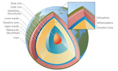
Composition of the Interior

Earth’s interior consists of the mantle and the core. The mantle and core make up by far the largest part of Earth’s mass. The distance from the base of the crust to the center of the core is about 6,400 km (about 4,000 mi).

Scientists have learned about Earth’s interior by studying rocks that formed in the interior and rose to the surface. The study of meteorites, which are believed to be made of the same material that formed the Earth and its interior, has also offered clues about Earth’s interior. Finally, seismic waves generated by earthquakes provide geophysicists with information about the composition of the interior. The sudden movement of rocks during an earthquake causes vibrations that transmit energy through the Earth in the form of waves. The way these waves travel through the interior of Earth reveals the nature of materials inside the planet.

The mantle consists of three parts: the lower part of the lithosphere, the region below it known as the asthenosphere, and the region below the asthenosphere called the lower mantle. The entire mantle extends from the base of the crust to a depth of about 2,900 km (about 1,800 mi). Scientists believe the asthenosphere is made up of mushy plastic-like rock with pockets of molten rock. The term asthenosphere is derived from Greek and means “weak layer.” The asthenosphere’s soft, plastic quality allows plates in the lithosphere above it to shift and slide on top of the asthenosphere. This shifting of the lithosphere’s plates is the source of most tectonic activity. The asthenosphere is also the source of the basaltic magma that makes up much of the oceanic crust and rises through volcanic vents on the ocean floor.

The mantle consists of mostly solid iron-magnesium silicate rock mixed with many other minor components including radioactive elements. However, even this solid rock can flow like a “sticky” liquid when it is subjected to enough heat and pressure.

The core is divided into two parts, the outer core and the inner core. The outer core is about 2,260 km (about 1,404 mi) thick. The outer core is a liquid region composed mostly of iron, with smaller amounts of nickel and sulfur in liquid form. The inner core is about 1,220 km (about 758 mi) thick. The inner core is solid and is composed of iron, nickel, and sulfur in solid form. The inner core and the outer core also contain a small percentage of radioactive material. The existence of radioactive material is one of the sources of heat in Earth’s interior because as radioactive material decays, it gives off heat. Temperatures in the inner core may be as high as 6650°C (12,000°F).

The Core and Earth’s Magnetism

Scientists believe that Earth’s liquid iron core is instrumental in creating a magnetic field that surrounds Earth and shields the planet from harmful cosmic rays and the Sun’s solar wind. The idea that Earth is like a giant magnet was first proposed in 1600 by English physician and natural philosopher William Gilbert. Gilbert proposed the idea to explain why the magnetized needle in a compass points north. According to Gilbert, Earth’s magnetic field creates a magnetic north pole and a magnetic south pole. The magnetic poles do not correspond to the geographic North and South poles, however. Moreover, the magnetic poles wander and are not always in the same place. The north magnetic pole is currently close to Ellef Ringnes Island in the Queen Elizabeth Islands near the boundary of Canada’s Northwest Territories with Nunavut. The south magnetic pole lies just off the coast of Wilkes Land, Antarctica.

Not only do the magnetic poles wander, but they also reverse their polarity—that is, the north magnetic pole becomes the south magnetic pole and vice versa. Magnetic reversals have occurred at least 170 times over the past 100 million years. The reversals occur on average about every 200,000 years and take place gradually over a period of several thousand years. Scientists still do not understand why these magnetic reversals occur but think they may be related to Earth’s rotation and changes in the flow of liquid iron in the outer core.

Some scientists theorize that the flow of liquid iron in the outer core sets up electrical currents that produce Earth’s magnetic field. Known as the dynamo theory, this theory appears to be the best explanation yet for the origin of the magnetic field. Earth’s magnetic field operates in a region above Earth’s surface known as the magnetosphere. The magnetosphere is shaped somewhat like a teardrop with a long tail that trails away from the Earth due to the force of the solar wind.

Inside the magnetosphere are the Van Allen radiation belts, named for the American physicist James A. Van Allen who discovered them in 1958. The Van Allen belts are regions where charged particles from the Sun and from cosmic rays are trapped and sent into spiral paths along the lines of Earth’s magnetic field. The radiation belts thereby shield Earth’s surface from these highly energetic particles. Occasionally, however, due to extremely strong magnetic fields on the Sun’s surface, which are visible as sunspots, a brief burst of highly energetic particles streams along with the solar wind. Because Earth’s magnetic field lines converge and are closest to the surface at the poles, some of these energetic particles sneak through and interact with Earth’s atmosphere, creating the phenomenon known as an aurora.

Earth's Future


With the rise of human civilization about 8,000 years ago and especially since the Industrial Revolution in the mid-1700s, human beings began to alter the surface, water, and atmosphere of Earth. In doing so, they have become active geological agents, not unlike other forces of change that influence the planet. As a result, Earth’s immediate future depends to a great extent on the behavior of humans. For example, the widespread use of fossil fuels is releasing carbon dioxide and other greenhouse gases into the atmosphere and threatens to warm the planet’s surface. This global warming could melt glaciers and the polar ice caps, which could flood coastlines around the world and many island nations. In effect, the carbon dioxide that was removed from Earth’s early atmosphere by the oceans and by primitive plant and animal life, and subsequently buried as fossilized remains in sedimentary rock, is being released back into the atmosphere and is threatening the existence of living things. See also Global Warming.

Even without human intervention, Earth will continue to change because it is geologically active. Many scientists believe that some of these changes can be predicted. For example, based on studies of the rate that the seafloor is spreading in the Red Sea, some geologists predict that in 200 million years the Red Sea will be the same size as the Atlantic Ocean is today. Other scientists predict that the continent of Asia will break apart millions of years from now, and as it does, Lake Baikal in Siberia will become a vast ocean, separating two landmasses that once made up the Asian continent.

In the far, far distant future, however, scientists believe that Earth will become an uninhabitable planet, scorched by the Sun. Knowing the rate at which nuclear fusion occurs in the Sun and knowing the Sun’s mass, astrophysicists (scientists who study stars) have calculated that the Sun will become brighter and hotter about 3 billion years from now, when it will be hot enough to boil Earth’s oceans away. Based on studies of how other Sun-like stars have evolved, scientists predict that the Sun will become a red giant, a star with a very large, hot atmosphere, about 7 billion years from now. As a red giant the Sun’s outer atmosphere will expand until it engulfs the planet Mercury. The Sun will then be 2,000 times brighter than it is now and so hot it will melt Earth’s rocks. Earth will end its existence as a burnt cinder. See also Sun.

Three billion years is the life span of millions of human generations, however. Perhaps by then, humans will have learned how to journey beyond the solar system to colonize other planets in the Milky Way Galaxy and find another place to call “home.”

Cloud Formation And Effects


The formation of clouds caused by cooling of the air results in the condensation of invisible water vapor that produces visible cloud droplets or ice particles. Cloud particles range in size from about 5 to 75 micrometers (0.0005 to 0.008 cm/0.0002 to 0.003 in). The particles are so small that light, vertical currents easily sustain them in the air. The different cloud formations result partly from the temperature at which condensation takes place. When condensation occurs at temperatures below freezing, clouds are usually composed of ice crystals; those that form in warmer air usually consist of water droplets. Occasionally, however, supercooled clouds contain water droplets at subfreezing temperatures. The air motion associated with cloud development also affects formation. Clouds that develop in calm air tend to appear as sheets or stratified formations; those that form under windy conditions or in air with strong vertical currents have a towering appearance.

Clouds perform a very important function in modifying the distribution of solar heat over the earth's surface and within the atmosphere (see Solar Energy). In general, because reflection from the tops of clouds is greater than reflection from the surface of the earth, the amount of solar energy reflected back to space is greater on cloudy days. Although most solar radiation is reflected back by the upper layers of the clouds, some radiation penetrates to the surface of the earth, which absorbs this energy and reradiates it. The lower parts of clouds are opaque to this long-wave earth radiation and reflect it back toward earth. The result is that the lower atmosphere generally absorbs more radiative heat energy on a cloudy day because of the presence of this trapped radiation. By contrast, on a clear day more solar radiation is initially absorbed by the surface of the earth, but when reradiated this energy is quickly dissipated because of the absence of clouds. Disregarding related meteorological elements, the atmosphere actually absorbs less radiation on clear days than on cloudy days.

Classification of Cloud

Clouds are usually divided into four main families on the basis of their height above the ground: high clouds, middle clouds, low clouds, and clouds with vertical development that may extend through all levels. The four main divisions are further subdivided into genera, species, and varieties, which describe in detail the appearance of clouds and the manner in which they are formed. More than 100 different kinds of clouds are distinguishable. Only the primary families and most important genera are described on the topics below.

A. High Clouds
B. Middle Clouds
C. Low Clouds
D. Clouds with Vertical Development

Why People Build Dams


People build dams to divert water out of rivers for use in other locations or to capture water and store it for later use. The volume of water flowing in any given river varies seasonally. In the spring and early summer, rivers typically swell with water from rainstorms and mountain snowmelt. In the drier months of late summer and autumn, many rivers slow to a trickle. Storage dams impound seasonal floodwater so it can be used during periods of little or no rainfall. The water that backs up against a storage dam forms an artificial lake, called a reservoir. Release of water from the reservoir can be controlled through systems of pipes or gates called outlet works.

A. Irrigation and Drinking Water

From ancient times to the present, people have built dams to capture water to irrigate crops in areas where rainfall does not provide enough ground moisture for plant growth. Simple irrigation systems often depend on small diversion dams that raise the height of a stream. Flowing water backs up against the dam until it overflows into a canal, ditch, or pipe that carries the water to fields.

B. Hydroelectric Power

Hydroelectric dams generate electricity (see Waterpower). Hydroelectric dams harness the energy of water released from the reservoir to turn hydraulic turbines. The turbines convert the energy of the falling water into mechanical energy, which is used to power electric generators.

C. Flood Control

Dams also protect low-lying areas from floods (see Flood Control). Floods occur when more rain falls than the soil and vegetation can absorb. The excess water runs off the land in greater quantities than rivers, streams, ponds, and wetlands can contain. Such heavy rains, and also snowmelt, periodically cause rivers to overflow their banks, spilling onto the surrounding floodplain. Ensuing floods can damage property and endanger the lives of people and animals.

D. Navigation

Dams help make inland waterways accessible to ships and barges. By inundating shallow, rocky streambeds and controlling the release of water from reservoirs, dams make rivers deep enough for ships and barges to pass through without running aground.

When a dam obstructs a navigable river, engineers build a canal adjacent to the dam to permit ships and barges to bypass the dam. Canals may incorporate one or more locks, which contain mechanisms to control the water level. Ships and barges are raised or lowered with changes in the water level in the lock. One gate in the lock then opens, enabling a vessel to exit to a higher or lower section of the waterway. Locks prevent water from rushing uncontrolled through the canal.